A Systematic and Comprehensive Technical Framework for Groundwater Exploration Using Geophysical Survey Methods
Groundwater Exploration Using Geophysical Methods: Comprehensive Technical Framework for Indonesia
Reading Time: 48 minutes
Key Highlights
• Multiple Geophysical Methods: Seven primary techniques available for groundwater exploration including electrical resistivity (most common, 70% of surveys), seismic refraction/reflection, electromagnetic methods, ground-penetrating radar, magnetic resonance sounding, gravity, and magnetic surveys, each offering distinct advantages for specific geological conditions and investigation objectives
• Cost-Effectiveness Range: Survey costs vary substantially from IDR 15-25 million per kilometer for basic electrical resistivity to IDR 150-300 million per square kilometer for comprehensive 3D seismic surveys, with typical exploration projects requiring IDR 200-800 million total investment depending on site complexity and target depth
• Success Rate Factors: Properly designed and executed geophysical surveys achieve 65-85% success in locating productive aquifers when integrated with geological mapping and hydrogeological analysis, compared to 20-40% success for drilling without geophysical guidance, representing 2-3x improvement in exploration efficiency
• Technological Advances: Recent innovations including multi-electrode resistivity imaging systems, airborne electromagnetic surveys, magnetic resonance sounding for direct water detection, time-domain electromagnetic methods, and integrated inversion algorithms improve resolution, reduce costs, and enable deeper investigations reaching 500+ meters compared to traditional 100-200 meter limitations
Executive Summary
Groundwater exploration using geophysical methods provides cost-effective, non-invasive approach for locating and characterizing aquifers prior to expensive drilling programs, enabling systematic investigation of subsurface conditions across large areas while minimizing environmental disturbance and capital risk. Geophysical techniques measure physical property variations in subsurface materials including electrical resistivity, seismic velocity, electromagnetic conductivity, density, magnetic susceptibility, and nuclear magnetic resonance response, with interpretation translating these measurements into hydrogeological information about aquifer location, geometry, hydraulic properties, and water quality indicators. Multiple geophysical methods exist offering complementary capabilities suited to different geological settings, investigation objectives, budget constraints, and technical requirements, with selection depending on site-specific conditions and project goals.1
Indonesian groundwater exploration faces diverse geological challenges spanning porous sedimentary aquifers in coastal plains and river valleys, fractured volcanic rock aquifers throughout archipelago, weathered crystalline basement in hilly and mountainous regions, and karst limestone aquifers in Java, Sulawesi, and eastern islands. Each geological setting presents distinct characteristics affecting geophysical method performance, with sedimentary aquifers typically amenable to resistivity and electromagnetic methods detecting variations in pore water salinity and saturation, while fractured rock aquifers require integrated approaches combining electrical methods for fracture zone detection with seismic techniques mapping geological structure and magnetic methods identifying rock type variations. Tropical weathering produces thick soil and saprolite covers masking bedrock conditions, requiring careful survey design and interpretation accounting for complex resistivity profiles where weathered zones may contain more groundwater than underlying fresh rock.
This comprehensive technical analysis examines geophysical methods applicable to groundwater exploration in Indonesian contexts, covering electrical resistivity methods including vertical electrical sounding and electrical resistivity tomography, seismic refraction and reflection techniques, electromagnetic methods spanning frequency domain and time domain systems, ground-penetrating radar for shallow investigations, magnetic resonance sounding for direct water detection, and supporting methods including gravity and magnetic surveys. Discussion provides theoretical foundations, field procedures, data processing and interpretation, cost-benefit analysis comparing methods, success rate factors, integration strategies, quality assurance requirements, and emerging technologies advancing groundwater geophysics capabilities. Real-world case studies demonstrate method applications across different geological settings with quantitative analysis of costs, timelines, and outcomes supporting informed decision-making for groundwater exploration programs.
Practical decision frameworks guide method selection based on investigation objectives, geological conditions, site access constraints, budget availability, and required information depth and resolution. Comparison matrices evaluate methods across dimensions including investigation depth capability, resolution, productivity, capital and operating costs, skill requirements, and geological setting suitability. Cost-benefit analysis quantifies economic implications of geophysical exploration versus direct drilling approaches, demonstrating that systematic geophysical surveys typically reduce total exploration costs by 30-50% through improved drilling success rates and reduced number of unproductive boreholes, while providing comprehensive understanding of subsurface hydrogeology impossible to achieve through drilling alone given practical limits on borehole density.
Electrical Resistivity Methods for Groundwater Exploration
Electrical resistivity techniques represent most widely applied geophysical methods for groundwater exploration, accounting for approximately 70% of groundwater-focused geophysical surveys globally due to strong correlation between electrical resistivity and groundwater-related parameters including saturation, salinity, clay content, and porosity. Method measures subsurface electrical resistivity by injecting direct current through electrode pairs and measuring resulting potential difference at other electrode pairs, with apparent resistivity calculated from current, voltage, and geometric factor depending on electrode configuration. Resistivity varies dramatically across geological materials ranging from very low values (1-10 ohm-meters) for clay-rich sediments and saline groundwater, through moderate values (10-100 ohm-meters) typical of freshwater-saturated sand and gravel, to high values (100-10,000+ ohm-meters) characterizing fresh bedrock and unsaturated materials, enabling differentiation of aquifer materials from confining units and identification of water-bearing zones.1
Two primary electrical resistivity approaches serve groundwater exploration with distinct capabilities and applications. Vertical Electrical Sounding (VES) investigates variation of resistivity with depth at specific locations through progressively expanding electrode spacing, providing one-dimensional resistivity models showing layered structure beneath each sounding point. VES proves economical for reconnaissance surveys covering large areas with measurements at discrete stations, suitable when subsurface structure shows primarily horizontal layering typical of sedimentary sequences. Electrical Resistivity Tomography (ERT) also called resistivity imaging deploys many electrodes along profiles or in 2D/3D arrays, systematically measuring resistivity for numerous electrode combinations and inverting data to produce detailed two-dimensional cross-sections or three-dimensional volumes showing lateral and vertical resistivity variations. ERT provides superior resolution of complex geological structures including faults, fracture zones, channels, and heterogeneous aquifers justifying higher costs through detailed characterization enabling optimal well placement.
Electrical Resistivity Method Technical Specifications:
Vertical Electrical Sounding (VES):
• Electrode configuration: Schlumberger or Wenner array with expanding spacing
• Investigation depth: 50-300 meters depending on maximum spacing and geology
• Data acquisition: 15-30 measurements per sounding taking 1-2 hours field time
• Processing: 1D inversion producing layered resistivity models
• Applications: Sedimentary aquifer exploration, depth to bedrock, groundwater salinity assessment
• Cost: IDR 15-25 million per kilometer of survey line (typical 5-10 soundings)
Electrical Resistivity Tomography (ERT):
• Electrode array: Multi-electrode systems with 24-96 electrodes per spread
• Investigation depth: 20-150 meters typically, up to 300m with large spacing
• Data acquisition: Automated measurement sequences, 200-2000 data points per profile
• Processing: 2D/3D inversion requiring specialized software and computing
• Applications: Fracture zone mapping, aquifer heterogeneity, contamination delineation
• Cost: IDR 40-80 million per kilometer of 2D profile, IDR 200-400 million per km² for 3D
Equipment Requirements:
• Resistivity meter: Modern systems with 0.1% accuracy, 1-5000 ohm measurement range
• Electrodes: Stainless steel stakes or porous pot electrodes for hard ground
• Cables: Multi-core cables for ERT, single wires for VES
• Power source: 12V batteries, generators, or AC power depending on system
• GPS: For accurate positioning, essential for ERT interpretation
• Data logger: Ruggedized laptop or field computer with inversion software
Interpretation Considerations:
• Equivalence: Multiple resistivity models may fit data equally, requiring geological constraints
• Suppression: Thin layers may not be resolved if significantly less than investigation depth
• Anisotropy: Layered geology shows different resistivity for horizontal vs vertical current
• Temperature effects: Resistivity decreases ~2% per °C requiring corrections
• Contamination: Saline or polluted groundwater shows very low resistivity
• Saturation: Partially saturated zones show intermediate resistivity between dry and wet values
Field procedures for electrical resistivity surveys require systematic approach ensuring data quality and safety. Site reconnaissance identifies suitable survey lines avoiding metallic infrastructure including pipelines, power lines, buried cables, and fences causing electromagnetic noise and current leakage. Electrode contact resistance must remain below 10 kilohms through wetting contact points or using bentonite mud in dry soils, with contact resistance measured and recorded. Survey lines should extend 1.5-2 times desired investigation depth beyond area of interest ensuring adequate data for inversion. Quality control includes reciprocal measurements where current and potential electrode pairs are swapped, with differences below 5% indicating good data quality, and repeated measurements verifying consistency. Modern automated systems perform these checks automatically flagging suspect data for operator attention.
Indonesian applications of electrical resistivity methods prove particularly effective for sedimentary coastal aquifers, alluvial deposits, and volcanic ash sequences where lateral continuity and porosity-controlled resistivity enable reliable interpretation. Challenges include thick weathered zones producing complex resistivity profiles, high soil moisture causing low contact resistance but also low signal penetration, and cultural noise from power infrastructure in urbanized areas requiring careful survey design and processing. Success rates for VES-guided drilling in Indonesian sedimentary aquifers typically exceed 75% when surveys adequately characterize subsurface structure and interpretation incorporates local geological knowledge, compared to 30-40% success for drilling without geophysical guidance based on surface geology alone.
Seismic Methods for Aquifer Characterization
Seismic methods detect variations in subsurface seismic wave velocity related to rock type, density, porosity, saturation, and mechanical properties, providing complementary information to electrical methods about aquifer geometry, lithology, and structure. Seismic refraction measures first arrival times of seismic waves traveling through subsurface layers, with interpretation determining velocity and thickness of layers based on travel time versus distance relationships. Seismic reflection analyzes reflected waves from subsurface boundaries, producing detailed cross-sections analogous to radar or ultrasound imaging showing geological structure and stratigraphy. Seismic velocity increases with density and consolidation, ranging from 300-800 m/s in unconsolidated sediments through 1,500-3,000 m/s in saturated unconsolidated materials to 3,000-6,000+ m/s in consolidated rock, with water saturation typically increasing velocity 20-50% compared to dry conditions enabling detection of water table and saturated zones.
Seismic refraction serves groundwater applications primarily for determining depth to bedrock or competent layers, mapping geological structure including faults and fracture zones, and characterizing overburden thickness and properties above target aquifers. Method requires velocity increase with depth creating refracting interfaces, limiting applications where velocity inversions exist such as low-velocity weathered zones beneath higher-velocity unweathered material. Seismic reflection provides superior resolution and detail for deeper targets, though higher costs and processing complexity limit applications primarily to major projects or research studies. Both methods require energy source generating seismic waves (sledgehammer, weight drop, explosive charges, or mechanical vibrators), array of geophones detecting ground motion, and recording system digitizing signals for processing and interpretation.
Seismic Method Technical Specifications:
Seismic Refraction:
• Geophone array: 12-48 geophones at 2-10 meter spacing for shallow work
• Energy source: 5-10 kg sledgehammer for shallow (<50m), explosives for deeper
• Investigation depth: 20-100 meters typically, up to 200m with explosive sources
• Data acquisition: Multiple shot points along line, forward and reverse profiling
• Processing: Travel time analysis, intercept time method, tomographic inversion
• Cost: IDR 30-50 million per kilometer of survey line
Seismic Reflection:
• Geophone array: 48-96+ channels with close spacing (2-5 meters)
• Energy source: Accelerated weight drop or small vibrator systems
• Investigation depth: 50-500 meters with appropriate source energy
• Data acquisition: Common midpoint stacking with multiple fold coverage
• Processing: Complex workflow including filtering, stacking, migration
• Cost: IDR 150-300 million per square kilometer of 3D survey
Key Velocity Ranges for Interpretation:
• Dry unconsolidated sediment: 300-800 m/s
• Water-saturated sediment: 1,500-2,200 m/s (approaching water velocity)
• Weathered volcanic rock: 800-2,000 m/s
• Fresh volcanic rock: 2,500-4,500 m/s
• Weathered crystalline rock: 1,000-2,500 m/s
• Fresh crystalline rock: 4,000-6,000 m/s
Advantages and Limitations:
• Advantages: Direct lithology information, structural detail, independent of groundwater salinity
• Limitations: Requires velocity increase with depth, costly for deep investigations
• Noise sensitivity: Cultural noise, wind, traffic interfere with weak signals
• Permit requirements: Explosives require special permits and safety procedures
• Seasonal factors: Ground conditions affect coupling, background noise varies
• Integration value: Combines excellently with resistivity for comprehensive characterization
Seismic methods prove particularly valuable in Indonesian volcanic terrains for mapping weathered zone thickness overlying fresh rock, identifying permeable volcanic ash layers within lava sequences, detecting fault zones controlling groundwater flow in fractured rock aquifers, and characterizing alluvial valley fill geometry in intermontane basins. Seismic velocity contrasts typically strong in volcanic settings where fresh lava flows (3,000-4,000 m/s) alternate with porous volcanic ash (1,200-2,000 m/s) and weathered zones (800-1,500 m/s), enabling clear layer differentiation. Integration with electrical resistivity provides powerful combination where seismic defines geometric structure and lithology while resistivity indicates water content and salinity, reducing interpretation ambiguity inherent in either method alone.
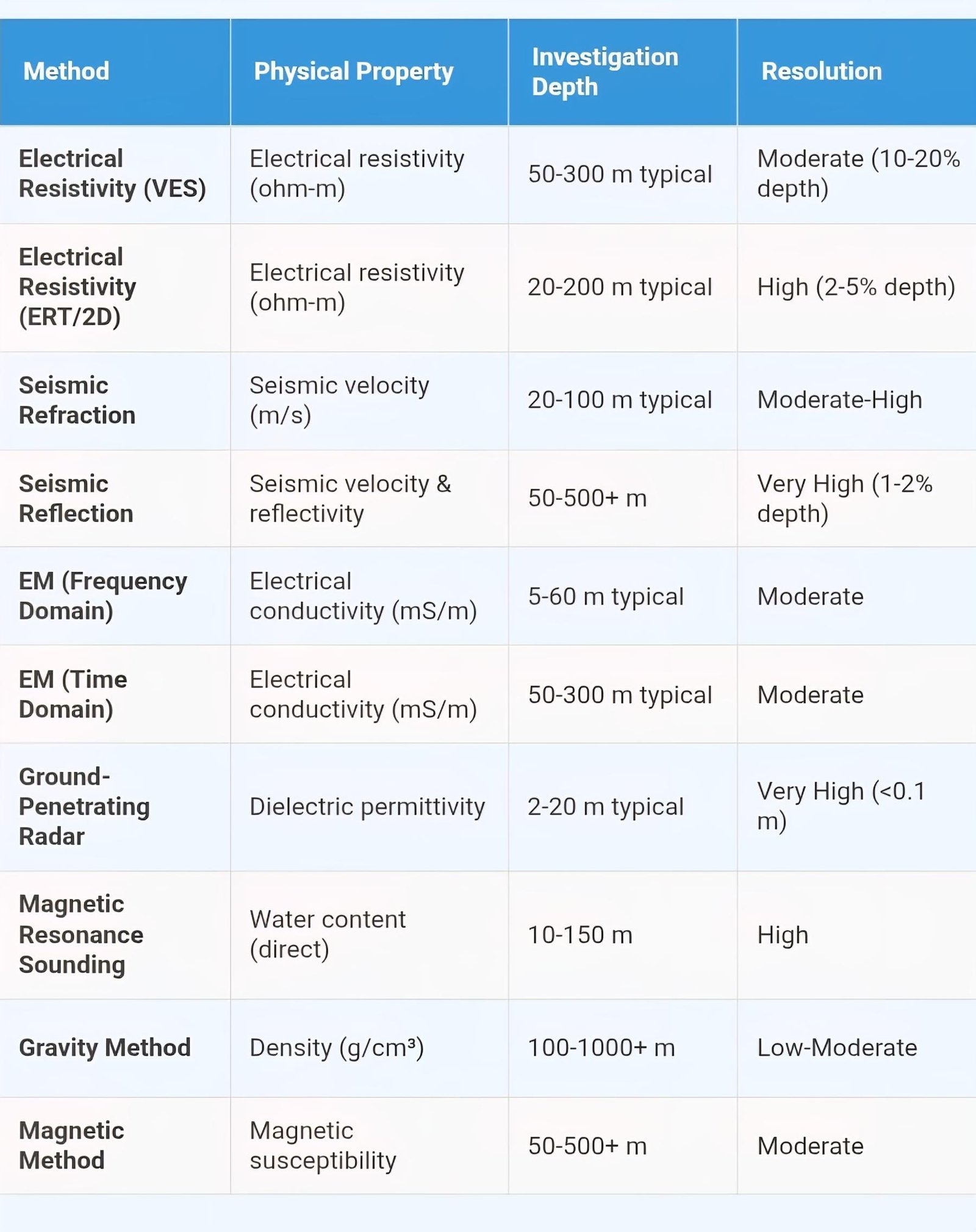
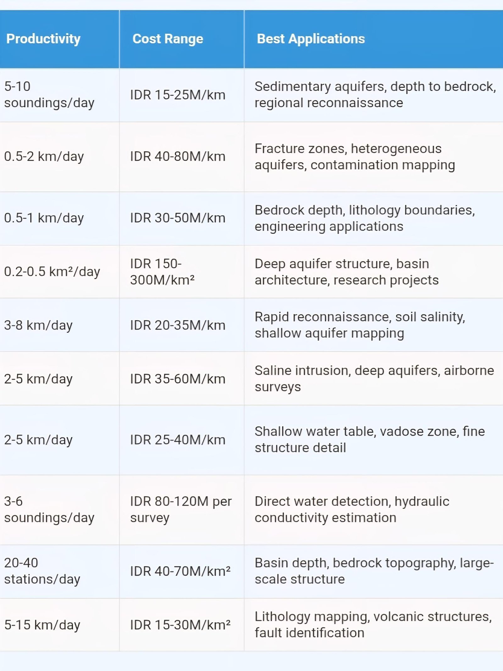
Geophysical Methods Comprehensive Comparison Matrix
Electromagnetic Methods for Groundwater Applications
Electromagnetic (EM) methods measure subsurface electrical conductivity through electromagnetic induction without requiring direct ground contact, offering faster data acquisition than electrode-based resistivity methods while providing complementary information about aquifer characteristics. EM techniques use transmitter coil generating time-varying primary magnetic field that induces electrical currents in conductive subsurface materials, which generate secondary magnetic fields detected by receiver coil with amplitude and phase relationships indicating subsurface conductivity distribution. Methods divide into frequency-domain systems transmitting continuous sinusoidal signals at one or more frequencies, and time-domain systems transmitting transient pulses and measuring decay of induced currents over time, with each approach offering distinct capabilities for groundwater exploration.
Frequency-domain electromagnetic (FDEM) systems operate at fixed frequencies typically ranging from 400 Hz to 100 kHz with multiple coil configurations providing investigation depths from few meters to approximately 60 meters depending on coil separation, frequency, and ground conductivity. Commonly used in reconnaissance mode, FDEM systems enable rapid data collection walking along profiles while continuously recording measurements at meter-scale intervals, covering 3-8 kilometers per day compared to 0.5-2 kilometers for electrical resistivity. Applications include rapid mapping of shallow aquifers, soil salinity surveys for agricultural planning, groundwater contamination delineation, and regional hydrogeological mapping identifying prospective zones for detailed investigation. Time-domain electromagnetic (TDEM) systems transmit high-power current pulses through large loop or grounded wire and measure induced voltage decay in receiver coil, with late-time measurements sampling deeper subsurface enabling investigation to 200-300 meters or more in resistive environments. TDEM proves effective for mapping saline groundwater interfaces, deep aquifer characterization, and mineral exploration though higher equipment costs and slower data acquisition than FDEM limit applications primarily to projects justifying premium capabilities.
Electromagnetic Method Technical Specifications:
Frequency-Domain Electromagnetic (FDEM):
• Systems: EM31, EM34, EM38 (Geonics Ltd), CMD (GF Instruments)
• Frequencies: 400 Hz to 100 kHz depending on instrument
• Investigation depth: 3-60 meters depending on coil spacing and orientation
• Productivity: 3-8 km per day for continuous profile mode
• Advantages: No ground contact, rapid data acquisition, good for mapping
• Cost: IDR 20-35 million per kilometer of survey
Time-Domain Electromagnetic (TDEM):
• Systems: TEM-FAST, Protem (Geonics), EM47/67 (IRIS Instruments)
• Transmitter loops: 25-200 meter squares or grounded wire
• Investigation depth: 50-300 meters typical, up to 500m in resistive conditions
• Productivity: 3-6 soundings per day with loop setup and teardown
• Advantages: Deep penetration, immune to surface resistivity
• Cost: IDR 35-60 million per kilometer of survey line
Airborne Electromagnetic (AEM):
• Systems: Helicopter-borne frequency or time-domain systems
• Survey speed: 80-120 km/hour enabling large area coverage
• Investigation depth: 50-400 meters depending on system and geology
• Applications: Regional aquifer mapping, saline interface, large projects
• Advantages: Very high productivity, access to remote areas
• Cost: IDR 500-1,500 million for mobilization plus IDR 40-80M per 100 km²
Interpretation Considerations:
• Conductivity mapping: Direct measurement of electrical conductivity (inverse of resistivity)
• Salinity sensitivity: Very sensitive to pore water salinity, excellent for saline intrusion
• Cultural interference: Power lines, fences, buried utilities cause strong anomalies
• Low induction number: Requires sufficient subsurface conductivity for signal
• 1D inversion: Layered earth interpretation similar to resistivity sounding
• Integration: Complements resistivity providing independent validation
Indonesian coastal aquifer investigations benefit substantially from electromagnetic methods for mapping freshwater-saltwater interfaces, identifying aquifer extent and thickness beneath tidal zones, and monitoring temporal changes in salinity distribution. FDEM surveys provide cost-effective reconnaissance identifying areas suitable for groundwater development versus those affected by seawater intrusion, while TDEM soundings characterize deep freshwater resources beneath thin saline surface layers common in coastal settings. Airborne electromagnetic surveys, though expensive requiring mobilization of aircraft and specialized equipment, enable regional-scale aquifer mapping across difficult terrain including swamps, dense forests, and remote islands where ground-based surveys prove logistically challenging and prohibitively expensive. Several successful AEM projects mapped groundwater resources across extensive areas in Kalimantan and Papua, demonstrating viability for major water supply investigations serving planned industrial developments or municipal expansions.
Advanced and Emerging Technologies
Recent technological advances expand geophysical groundwater exploration capabilities through improved resolution, deeper investigation, direct water detection, and reduced costs enabling more comprehensive aquifer characterization. Magnetic Resonance Sounding (MRS) also called Surface Nuclear Magnetic Resonance represents revolutionary technology providing direct, non-invasive measurement of subsurface water content and hydraulic properties without requiring boreholes. MRS operates by transmitting oscillating magnetic field at Larmor frequency specific to hydrogen nuclei in water molecules, exciting nuclear magnetic resonance in subsurface water, then measuring amplitude and relaxation time of resulting electromagnetic signal encoding information about water quantity, pore size distribution, and hydraulic conductivity. Unlike other geophysical methods measuring proxy properties requiring hydrogeological interpretation, MRS directly detects water enabling unambiguous identification of aquifers while estimating hydraulic parameters critical for water supply design.
MRS technology addresses fundamental limitation of conventional geophysics where multiple geological scenarios may produce similar geophysical signatures, creating interpretation ambiguity particularly in complex geological settings. Direct water detection eliminates uncertainty about whether conductive zones detected by electrical methods represent water-saturated sand, clay, or other lithologies, while hydraulic conductivity estimates reduce need for extensive aquifer testing providing preliminary design parameters before expensive drilling programs commence. However, MRS faces practical challenges including high equipment costs (USD 150,000-300,000 systems), electromagnetic noise sensitivity requiring measurements in areas away from power infrastructure, relatively low productivity (3-6 soundings per day), and investigation depth limitations (typically 10-150 meters depending on signal strength and noise levels). Despite limitations, MRS proves valuable for high-priority investigations where direct water information justifies premium costs, particularly in geologically complex areas where conventional methods produce ambiguous results.
Emerging Technology Capabilities:
Magnetic Resonance Sounding (MRS):
• Direct measurement: Water content (m³/m³) and hydraulic conductivity (m/s)
• Investigation depth: 10-150 meters depending on water content and noise
• Equipment: Specialized systems (NUMIS, IRIS Instruments; Vista Clara)
• Applications: Unambiguous aquifer identification, K estimation, complex geology
• Advantages: Direct water detection, quantitative hydraulic properties
• Limitations: Expensive equipment, noise sensitive, specialized expertise required
• Cost: IDR 80-120 million per multi-sounding survey area
Multi-Electrode Resistivity Imaging Systems:
• Automated systems: AGI SuperSting, ABEM Terrameter LS, Syscal Pro
• Electrode capacity: 64-156 channels with distributed switching units
• Productivity improvement: 3-5x faster than manual systems
• 3D capabilities: True volumetric imaging with grid electrode arrays
• Remote operation: Wireless control enabling hazardous area surveys
• Real-time QC: Instant data quality assessment and error flagging
Airborne Geophysical Systems:
• AEM systems: Frequency and time-domain helicopter-borne electromagnetic
• Magnetic/radiometric: Simultaneous acquisition with EM for lithology
• Production rates: 100-500 km² per day depending on line spacing
• Applications: Regional mapping, inaccessible terrain, large projects
• Data products: Conductivity depth sections, 3D voxel models
• Cost trends: Decreasing through improved efficiency and competition
Integrated Inversion and Interpretation:
• Joint inversion: Simultaneous inversion of multiple geophysical datasets
• Petrophysical relationships: Linking geophysics to hydrogeological properties
• Uncertainty quantification: Bayesian methods characterizing interpretation confidence
• Machine learning: AI-assisted interpretation and anomaly detection
• 3D visualization: Immersive rendering of subsurface models
• Cloud computing: Web-based processing and collaborative interpretation
Multi-electrode resistivity imaging systems represent significant practical advance improving productivity and data quality through automated measurement sequences, distributed switching reducing cable lengths and setup time, wireless control enabling remote operation, and real-time quality control flagging suspect data immediately rather than discovering problems during post-processing. These systems reduce field crew size requirements from 3-4 personnel to 2 people while increasing daily productivity by factor of 3-5, substantially improving project economics despite higher equipment capital costs. Three-dimensional resistivity imaging capabilities enable true volumetric aquifer characterization rather than interpolating between 2D profiles, providing superior understanding of complex three-dimensional geological structures including fault zones, paleochannels, and heterogeneous volcanic sequences common throughout Indonesia.
Integrated inversion approaches simultaneously process multiple geophysical datasets constraining interpretation and reducing ambiguity inherent in single-method inversions. Joint inversion of electrical resistivity and seismic data provides powerful combination where seismic defines geometric structure while resistivity indicates water content and salinity, with joint framework ensuring consistency between independent measurements while resolving features neither method alone constrains adequately. Petrophysical relationships linking geophysical properties to hydrogeological parameters enable quantitative estimation of porosity, hydraulic conductivity, and other properties from calibrated geophysical data, transforming geophysics from qualitative aquifer delineation to quantitative hydrogeological characterization supporting groundwater modeling and water supply design. Machine learning algorithms trained on extensive datasets increasingly assist interpretation through pattern recognition, anomaly detection, and automated classification, though human expertise remains essential validating results and incorporating geological understanding.
Geophysical Method Selection Decision Framework
Scenario 1: Sedimentary Coastal Aquifer Exploration
Geological Setting: Alluvial deposits, concern about saline intrusion
Investigation Objectives: Aquifer extent, freshwater-saltwater interface
Recommended Methods:
• Primary: Electrical Resistivity (VES or ERT) - excellent sensitivity to salinity
• Complementary: Time-Domain EM for deep interface mapping
• Validation: Seismic refraction for lithology boundaries
Rationale: Resistivity provides highest resolution for salinity variations, TDEM maps deeper zones, seismic confirms sediment vs bedrock
Scenario 2: Fractured Volcanic Rock Aquifer
Geological Setting: Andesitic lava flows with fracture zones
Investigation Objectives: Fracture zone location, weathered zone thickness
Recommended Methods:
• Primary: Electrical Resistivity Tomography (ERT) - maps fracture networks
• Complementary: Seismic refraction - defines rock quality and layering
• Supporting: Magnetic survey - identifies lava flow boundaries
Rationale: ERT detects water-filled fractures (low resistivity), seismic confirms weathering grade, magnetic maps lithology
Scenario 3: Regional Reconnaissance Survey
Geographical Scope: 100+ km² area requiring preliminary assessment
Investigation Objectives: Identify prospective zones for detailed study
Recommended Methods:
• Primary: Frequency-Domain EM - rapid coverage, good for mapping
• Alternative: Airborne EM if budget >IDR 1 billion and terrain difficult
• Follow-up: VES at selected locations for depth information
Rationale: FDEM provides cost-effective regional mapping, AEM for large/remote areas, VES for point detail
Scenario 4: Deep Aquifer Characterization (>200m)
Geological Setting: Deep sedimentary basin, target aquifer at 200-400m depth
Investigation Objectives: Deep aquifer geometry and properties
Recommended Methods:
• Primary: Time-Domain EM - deep penetration capability
• Complementary: Gravity survey - basin structure and depth
• Optional: Seismic reflection if major project (>IDR 5B budget)
Rationale: TDEM reaches required depth, gravity maps basin geometry, seismic provides detail for large budgets
Scenario 5: Shallow Aquifer and Water Table Mapping
Geological Setting: Shallow unconfined aquifer, water table at 5-15m depth
Investigation Objectives: Water table configuration, vadose zone characterization
Recommended Methods:
• Primary: Ground-Penetrating Radar - excellent shallow resolution
• Alternative: Frequency-Domain EM (EM31/38) for rapid mapping
• Complementary: Shallow VES or small-spacing ERT
Rationale: GPR provides highest resolution for shallow depths, EM offers speed, resistivity for deeper context
Scenario 6: Contamination Delineation
Environmental Context: Suspected groundwater contamination, plume mapping needed
Investigation Objectives: Contaminant plume extent, migration pathways
Recommended Methods:
• Primary: Electrical Resistivity Tomography (2D/3D) - maps conductive plumes
• Complementary: GPR for shallow contaminants in low-clay environments
• Time-series: Repeat surveys monitoring plume evolution
Rationale: ERT detects conductivity changes from dissolved contaminants, GPR shows phase contrasts, time-lapse tracks changes
Cost-Benefit Analysis and Economic Justification
Economic analysis of geophysical exploration versus alternative approaches demonstrates substantial value proposition for systematic surveys prior to drilling programs, particularly for projects requiring multiple boreholes or targeting uncertain aquifers where drilling risks and costs prove significant. Direct drilling without geophysical guidance relies on surface geological mapping, existing well data, and local hydrogeological knowledge producing success rates typically 30-45% in favorable geological settings but dropping below 20% in complex geology where surface features poorly indicate subsurface aquifer conditions. Failed boreholes represent sunk costs providing minimal information value beyond confirming absence of aquifer at specific location, while successful wells may encounter unexpected conditions including inadequate yields, poor water quality, or excessive depths requiring additional drilling elsewhere. Geophysical surveys reduce these risks through systematic subsurface characterization identifying optimal drilling locations and providing advance warning of challenging conditions enabling contingency planning.
Comparative cost analysis for typical groundwater development project targeting 50-100 m³/hour production capacity from 3-5 production wells illustrates geophysical value proposition. Direct drilling approach might drill 8-12 exploration boreholes at IDR 150-250 million each (depending on depth and drilling conditions) seeking productive zones, with 30-40% success rate producing 3-5 successful wells at total exploration cost of IDR 1.2-3.0 billion including failed holes. Geophysical approach invests IDR 200-500 million in comprehensive surveys (depending on method selection and area size) followed by targeted drilling of 4-6 boreholes at prime locations identified through geophysical interpretation, achieving 70-80% success rate producing required wells at total cost of IDR 800-1.8 billion including geophysics and drilling. Net savings of 25-40% result from improved drilling success reducing wasted expenditure on unproductive holes, while additional benefits include enhanced understanding of aquifer geometry and properties supporting optimal well design, pumping test interpretation, and water supply sustainability assessment.
Cost-Benefit Analysis Framework:
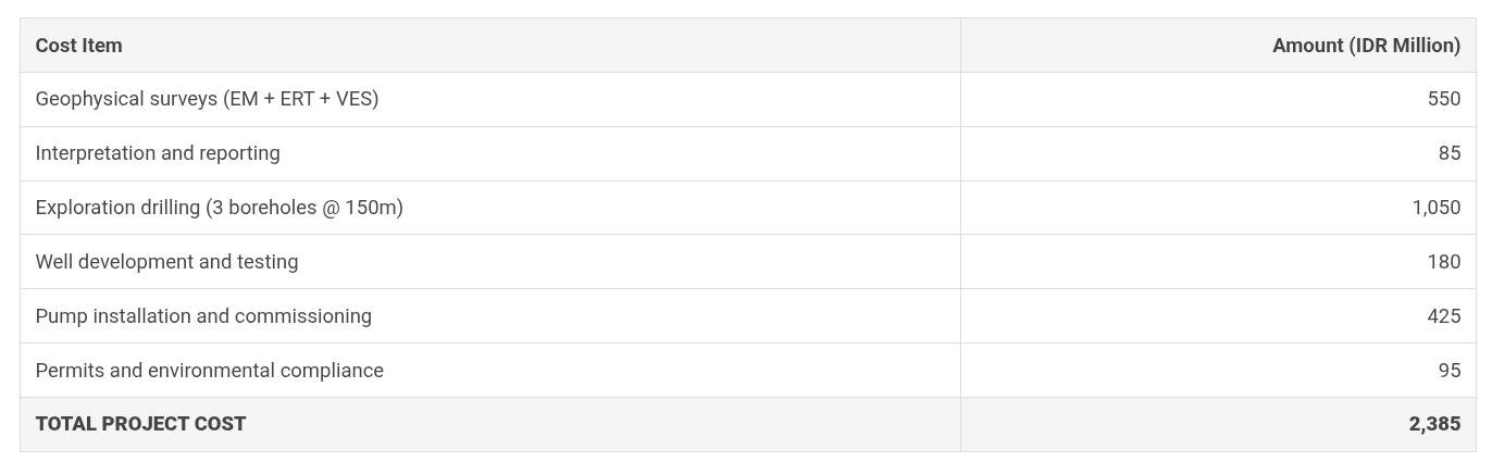
Typical Project Costs (50-100 m³/hour supply, 100-150m depth wells):
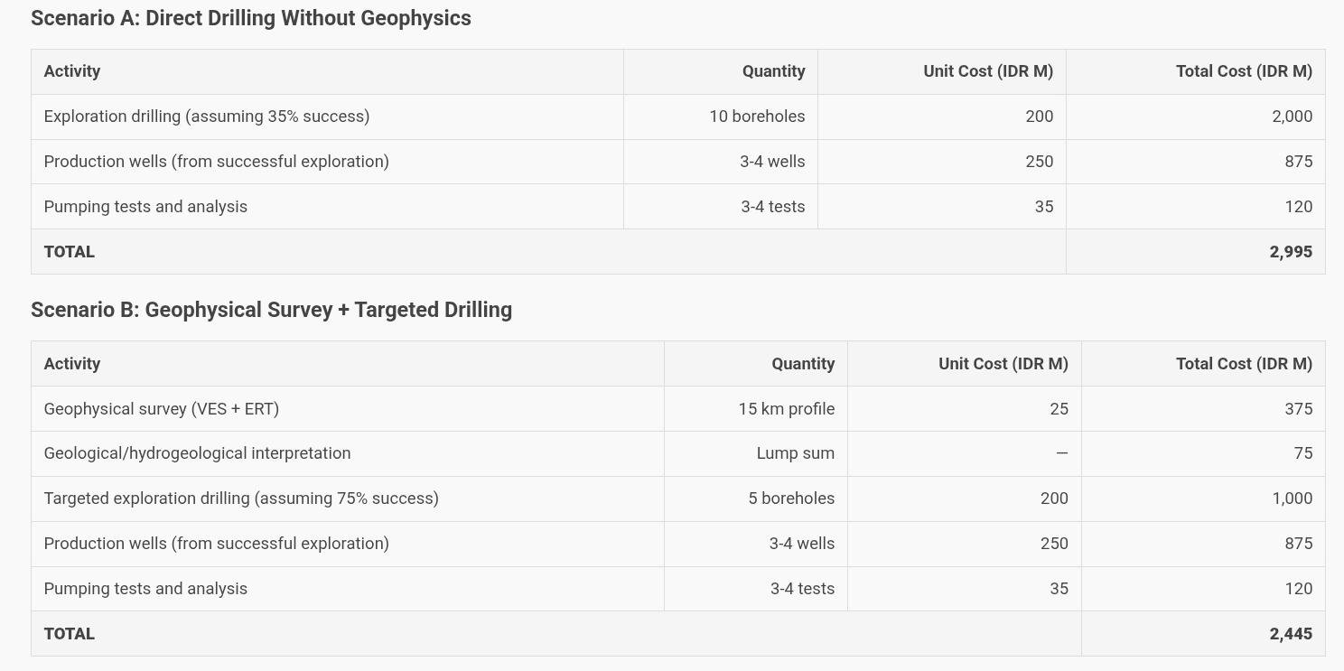
Net Cost Savings: IDR 550 Million (18.4%)
Geophysical approach saves IDR 550M through reduced drilling of unproductive holes while providing comprehensive aquifer characterization supporting optimal system design. Additional non-quantified benefits include reduced project timeline (fewer drilling mobilizations), lower environmental impact (fewer unnecessary boreholes), and superior hydrogeological understanding supporting sustainable water resource management.
Additional economic benefits beyond direct cost savings include reduced project timeline through systematic planning and targeted drilling avoiding iterative trial-and-error approaches, lower environmental and social impacts from minimized land disturbance and reduced drilling activities, enhanced hydrogeological understanding enabling optimal well design and pump selection, better aquifer management through comprehensive characterization supporting sustainable yield determination, and reduced long-term risks from unexpected conditions including insufficient capacity, water quality problems, or aquifer depletion. These qualitative benefits prove difficult quantifying precisely but represent substantial value particularly for major water supply projects serving municipalities, industries, or commercial developments where water security and long-term sustainability constitute critical success factors justifying premium for thorough planning and characterization.
Success Rates and Performance Factors
Geophysical survey success rates for groundwater exploration depend heavily on multiple factors including geological complexity, method selection appropriateness, survey design quality, data acquisition procedures, interpretation expertise, and integration with hydrogeological analysis. Well-designed and properly executed surveys in favorable geological settings achieve success rates of 75-85% defining productive aquifer zones and guiding drilling to successful wells, while poorly designed surveys, inappropriate method selection, or inadequate interpretation produce results no better than random drilling despite incurring survey costs. Understanding factors controlling success enables realistic expectations, appropriate project planning, and quality assurance measures maximizing probability of positive outcomes justifying geophysical investment.
Geological favorability represents most critical success factor, with sedimentary aquifers in relatively simple geological settings amenable to high success rates through straightforward application of standard methods, while fractured rock aquifers in complex geological structures present greater challenges requiring integrated multi-method approaches and sophisticated interpretation. Targets showing strong geophysical contrast with surrounding materials enable confident identification, such as freshwater sand aquifers in clay-rich sequences showing high resistivity, while subtle contrasts including slightly fractured rock versus intact rock require careful survey design and interpretation. Investigation depth relative to target depth affects success, with shallow targets within several tens of meters generally more reliably characterized than deep targets at 200-300 meters requiring specialized methods and favorable conditions. Site access and cultural noise constraints limit survey design options and data quality in urban or developed areas, potentially degrading success compared to rural sites enabling optimal survey implementation.
Success Rate Factors and Mitigation Strategies:
Favorable Factors (Supporting High Success Rates):
• Simple geology: Layered sedimentary sequences, predictable lithology
• Strong contrasts: Large differences in electrical, seismic, or EM properties
• Shallow targets: Investigation depth <100m within most methods' capabilities
• Rural sites: Minimal cultural noise, good site access, optimal survey design
• Multiple methods: Integrated surveys resolving interpretation ambiguities
• Experienced interpretation: Specialists with local geological knowledge
• Validation data: Existing wells, outcrops, geological maps constraining interpretation
Challenging Factors (Requiring Mitigation):
• Complex geology: Faults, folding, heterogeneity complicating interpretation
• Subtle contrasts: Similar properties making differentiation difficult
• Deep targets: >200m depths exceeding many methods or requiring expensive approaches
• Urban settings: Power lines, buildings, buried utilities causing interference
• Single method: Interpretation ambiguity from insufficient information
• Inexperienced interpretation: Lack of local knowledge or geological context
• No validation: Absence of control data for calibration and verification
Quality Assurance Measures:
• Pilot survey: Small test survey validating method effectiveness before full deployment
• Method comparison: Multiple methods at select locations confirming consistency
• Error analysis: Quantifying measurement uncertainty and propagation to interpretation
• Alternative models: Testing multiple interpretation scenarios against data
• Validation drilling: Early drilling at geophysically-defined target verifying predictions
• Peer review: Independent expert review of interpretation and recommendations
• Contingency planning: Alternative approaches if initial methods prove inadequate
Typical Success Rates by Geological Setting:
• Sedimentary coastal/alluvial aquifers: 75-85% with appropriate methods
• Volcanic ash/lapilli sequences: 70-80% when weathering not extreme
• Fractured volcanic rock: 60-75% with integrated multi-method approach
• Fractured crystalline rock: 55-70%, highly dependent on fracture development
• Karst limestone: 40-60%, very heterogeneous and difficult to characterize
• Complex fault zones: 50-65%, structural complexity complicating interpretation
Survey design quality profoundly influences success through appropriate method selection matching investigation objectives and geological conditions, adequate survey density providing sufficient data for reliable interpretation, suitable electrode/geophone spacing optimizing investigation depth and resolution tradeoff, and profile orientation perpendicular to geological strike maximizing structure detectability. Indonesian practitioners should avoid common pitfalls including undersized surveys with insufficient coverage, inappropriate methods for geological conditions, excessive electrode spacing sacrificing resolution, parallel profiles missing key structures, and inadequate quality control procedures failing to detect data problems before processing. International best practices documented in cited references provide detailed guidance for survey planning, execution, and interpretation supporting high-quality results.
Interpretation expertise represents critical yet often underestimated success factor, with experienced hydrogeophysicists producing substantially superior results compared to inexperienced practitioners through recognition of data artifacts, awareness of interpretation pitfalls, incorporation of geological constraints, realistic assessment of alternatives, and communication of uncertainty ranges rather than false precision. Organizations conducting geophysical exploration should invest in staff training, engage qualified consultants for major projects, seek peer review for critical interpretations, and maintain realistic expectations about method capabilities and limitations. Promising results require verification drilling before committing to full production well development, with validation confirming predictions building confidence while unexpected results prompting reassessment and potential supplementary investigations.
Real Project Case Study: Industrial Water Supply Exploration
Project Overview:
Location: Cikarang industrial estate, West Java
Client: Manufacturing facility requiring reliable water supply
Water Requirement: 150 m³/hour continuous (3,600 m³/day)
Geological Setting: Alluvial deposits overlying volcanic bedrock
Project Duration: 4 months from survey to production well completion
Budget Available: IDR 2.5 billion for complete exploration and development
Success Criteria: Sustainable yield meeting requirement, water quality suitable for industrial use
Geophysical Investigation Program:
Phase 1: Reconnaissance (Week 1-2)
• Geological mapping and existing well data compilation
• Frequency-domain EM survey (EM34): 8 km of profiles, cost IDR 180M
• Result: Identified 3 prospective zones with lower conductivity (freshwater indicators)
Phase 2: Detailed Investigation (Week 3-5)
• Electrical resistivity tomography: 4 profiles totaling 3.2 km, cost IDR 220M
• Vertical electrical sounding: 12 soundings at key locations, cost IDR 150M
• Result: Defined aquifer geometry, estimated thickness 25-40m at 60-90m depth
Interpretation and Site Selection (Week 6-7)
• Integrated interpretation combining EM, ERT, and VES data
• Cross-section development showing subsurface structure
• Selected 3 optimal drilling locations based on thick aquifer zones
Drilling Program and Validation:

Drilling Success Rate: 100% (3/3 boreholes productive)
Depth Prediction Accuracy: ±3-5 meters (excellent agreement)
Total Sustainable Yield: 258 m³/hour (exceeds 150 m³/h requirement by 72%)
Water Quality: TDS 180-220 mg/L, suitable for industrial use with minimal treatment
Cost Analysis and ROI:
Comparison to Direct Drilling Scenario:
• Estimated 6-8 boreholes needed without geophysics @ IDR 350M each = IDR 2,100-2,800M drilling alone
• Additional costs for failed holes, delays, and uncertainty = IDR 300-500M
Estimated savings: IDR 400-900 million plus 4-6 weeks timeline reduction
Lessons Learned and Best Practices:
Success Factors:
• Multi-method approach (EM + resistivity) resolved interpretation ambiguities
• Adequate survey density provided confident aquifer delineation
• Integration with geological knowledge constrained interpretation
• Quality control procedures ensured reliable data
Key Metrics:
• Geophysical cost as % of total: 27% (typical 20-30% range)
• Drilling success rate: 100% (vs 30-40% without geophysics)
• Project timeline: 16 weeks (vs estimated 24-28 weeks direct drilling)
• Cost efficiency: Completed 5% under budget with superior results
Frequently Asked Questions About Groundwater Geophysics
1. What is the most cost-effective geophysical method for groundwater exploration in Indonesia?
Electrical resistivity methods, particularly vertical electrical sounding (VES), represent most cost-effective approach for majority of Indonesian groundwater projects, costing IDR 15-25 million per kilometer of survey line while providing reliable aquifer characterization in sedimentary and volcanic settings comprising most of Indonesian archipelago. VES surveys achieve good investigation depths (50-300 meters) suitable for typical water supply wells, require relatively modest equipment investment (IDR 150-300 million for complete system), and leverage widely available interpretation software and expertise. For specialized situations including deep aquifer exploration (>200m), fractured rock characterization, or contamination studies, more expensive methods like time-domain electromagnetic, electrical resistivity tomography, or magnetic resonance sounding may justify higher costs through superior capabilities. Method selection should always consider specific project objectives, geological conditions, and budget constraints rather than assuming universal superiority of any single technique.
2. How deep can geophysical methods investigate for groundwater applications?
Investigation depth varies substantially by method and site conditions, with electrical resistivity typically reaching 50-300 meters depending on electrode spacing and subsurface resistivity distribution, seismic refraction investigating 20-100 meters with conventional energy sources, ground-penetrating radar limited to 2-20 meters in typical Indonesian conditions, time-domain electromagnetic achieving 50-300 meters or more in resistive environments, and gravity/magnetic methods sensitive to deep structures but lacking resolution for aquifer detail. Increasing investigation depth generally requires larger survey geometries (wider electrode spacing, longer seismic spreads, bigger electromagnetic loops) and more powerful energy sources, with practical limits from signal-to-noise degradation, cultural interference, and site access constraints. Most Indonesian water supply wells target depths of 50-200 meters where electrical resistivity and electromagnetic methods provide cost-effective characterization, while deeper targets may require specialized approaches like deep-probing TDEM systems, seismic reflection, or combined methods. Survey design should establish target depth requirements during planning phase ensuring selected methods possess adequate capability while recognizing that resolution degrades with increasing depth.
3. Can geophysical methods determine water quality or only locate aquifers?
Geophysical methods provide indicators of water quality particularly regarding salinity and total dissolved solids, though cannot directly measure specific chemical constituents without borehole sampling. Electrical resistivity and electromagnetic methods prove highly sensitive to pore water salinity since dissolved ions conduct electrical current, enabling distinction between freshwater aquifers (showing high resistivity or low conductivity) and saline groundwater (showing low resistivity or high conductivity). Quantitative interpretation requires calibration relationships linking electrical properties to TDS concentration, typically established through comparison with water samples from existing wells or validation drilling. Other water quality parameters including hardness, pH, nitrate, and contaminants cannot be determined directly from geophysics requiring water sampling and laboratory analysis. Magnetic resonance sounding provides unique capability estimating pore size distribution relating to hydraulic conductivity, though not chemical quality. Practical approach combines geophysical surveys identifying aquifer location, geometry, and salinity indicators with targeted water sampling from validation boreholes or existing wells characterizing complete water quality for specific applications. Geophysics excels at delineating spatial variations in salinity including mapping saline intrusion in coastal areas or contamination plumes from point sources.
4. What is typical timeline for geophysical groundwater exploration project?
Project timeline depends on survey scale, method selection, logistical constraints, and interpretation complexity, with typical moderate-scale project (10-20 km of survey lines or 5-10 km² area) requiring 4-8 weeks from mobilization to final report. Breakdown includes project planning and site preparation (0.5-1 week), field data acquisition (1-3 weeks depending on method productivity and site access), data processing and quality control (0.5-1 week), interpretation and modeling (1-2 weeks), and report preparation and review (0.5-1 week). Multiple methods increase timeline through additional fieldwork though interpretation may progress in parallel. Large regional surveys covering 50-100+ km² may require 2-4 months particularly for methods like seismic reflection or if remote locations complicate logistics. Airborne surveys offer dramatically shorter acquisition (days rather than weeks) though mobilization, planning, and permitting may require several months. Post-geophysical validation drilling adds 2-4 weeks per borehole including mobilization, drilling, testing, and analysis. Complete exploration programs from initial geophysics through production well development typically span 3-6 months for projects with 3-5 production wells. Rush projects may compress timeline through mobilization of additional crews, extended work hours, or staged reporting though cannot eliminate fundamental requirements for quality data acquisition and careful interpretation.
5. What qualifications should geophysical contractors possess for groundwater work?
Qualified geophysical contractors should demonstrate technical staff with relevant education (geophysics, geoscience, or related fields), practical experience in groundwater applications specifically rather than only mineral exploration or engineering geophysics which employ different approaches, ownership or access to appropriate modern equipment in good working condition with valid calibration, demonstrated quality assurance procedures including data validation and error analysis, professional indemnity insurance covering survey activities and interpretations, and references from previous groundwater clients verifiable through direct contact. Key personnel should include field geophysicist supervising data acquisition with training in specific methods employed, geophysical interpreter with hydrogeological understanding translating geophysical data to water resource implications, and project manager coordinating activities and client communication. Indonesian practitioners should preferably possess relevant certifications from professional organizations like Indonesian Geophysicists Association (HAGI) or international equivalents, though practical experience and demonstrated results prove more important than credentials alone. Client due diligence should request detailed proposals describing methodology, equipment specifications, personnel qualifications, project timeline, deliverables, and cost breakdown, while checking references from similar projects and reviewing example reports assessing interpretation quality and presentation standards.
6. How accurate are geophysical predictions compared to actual drilling results?
Geophysical prediction accuracy varies by parameter and geological complexity, with depth predictions to major interfaces (bedrock, water table, aquifer top) typically achieving ±5-10% accuracy in favorable conditions while thickness estimates and lithological interpretations show greater uncertainty requiring validation drilling. Resistivity inversions commonly produce depth errors of ±10-20% for deep layers due to equivalence where multiple models fit data equally well, necessitating geological constraints for unique interpretation. Aquifer properties including hydraulic conductivity cannot be predicted precisely from geophysics alone, though magnetic resonance sounding provides hydraulic parameter estimates within factor of 2-3 after calibration. Lateral positioning accuracy depends on survey spacing, with aquifer boundaries typically located within measurement spacing (tens to hundreds of meters depending on method). Case studies document drilling success rates of 70-85% for geophysically-targeted boreholes versus 30-45% without geophysics, with successful wells generally confirming major geophysical predictions though often showing detail variations from interpreted models. Realistic expectations recognize geophysics provides probability-based guidance rather than certainty, with confidence improving through multi-method approaches, dense survey coverage, geological constraints, and validation drilling. Clients should view geophysics as significantly improving exploration efficiency and understanding while accepting residual uncertainty inherent in remote sensing of complex subsurface eliminated only by direct drilling verification.
7. What environmental or safety considerations apply to geophysical surveys?
Geophysical surveys represent relatively low environmental impact activities compared to drilling, though specific considerations apply including electrical safety when operating resistivity systems using injected current requiring proper grounding and safety procedures preventing electrical hazards, seismic source safety when using explosive charges requiring special permits and trained blasters following strict protocols, electromagnetic compatibility avoiding interference with sensitive electronic equipment or medical devices, and site access minimizing vegetation disturbance and erosion particularly on slopes or sensitive areas. Indonesian regulations typically require environmental permits for surveys in protected areas, forestry lands, or near water bodies, while community liaison proves essential obtaining access permissions and minimizing conflicts with land users. Field crews should follow standard safety protocols including personal protective equipment, emergency communication procedures, first aid capabilities, and hazard awareness particularly for tropical hazards including snakes, unstable terrain, and weather extremes. Most geophysical methods produce no permanent ground disturbance beyond minor electrode holes or seismic shot holes readily backfilled, though survey lines should avoid archaeological sites, cemeteries, and culturally sensitive locations. Seismic reflection using heavy vibrator trucks may require road reinforcement or access improvements potentially impacting environment. Overall environmental footprint remains minimal compared to drilling alternatives, providing significant advantage for investigations in protected or sensitive areas.
8. Can geophysical surveys be conducted in urban or developed areas?
Urban geophysical surveys prove feasible though present challenges requiring specialized approaches and careful planning addressing cultural noise from power lines, buried utilities, metal structures, and electromagnetic interference affecting data quality, limited site access with surveys constrained to roads, parks, or available spaces rather than optimal geological orientations, traffic and public safety requiring traffic management and safety barriers, and complex permissions involving multiple property owners, utilities, and municipal authorities. Methods vary in urban tolerance, with electrical resistivity and seismic techniques relatively robust though requiring noise avoidance or filtering, while electromagnetic and magnetic methods prove very sensitive to metallic infrastructure limiting applicability. Ground-penetrating radar functions effectively for shallow investigations identifying buried utilities and shallow groundwater. Urban survey modifications include shorter electrode/geophone spacing providing shallow focus, profile orientations following available access rather than geological strike, measurement timing during low-traffic periods reducing noise, and increased measurement duration improving signal-to-noise ratio. Advanced processing including noise filtering, robust statistics, and data editing removes interference effects. Despite challenges, many successful urban groundwater surveys demonstrate feasibility using appropriate methods, survey design modifications, noise mitigation strategies, and experienced interpretation recognizing urban signatures. Alternative approaches include surveys in adjacent less-developed areas extrapolating to urban targets, or reliance on existing well data and direct drilling if geophysics proves impractical.
9. What data and deliverables should be expected from geophysical contractor?
Comprehensive geophysical project deliverables should include field data in standard digital formats enabling independent verification and reprocessing, processed data showing quality control and data reduction procedures, interpreted models presented as cross-sections, maps, and 3D visualizations as appropriate, comprehensive technical report documenting methodology, equipment specifications, field procedures, processing parameters, interpretation approach, results, and recommendations, and GIS-compatible datasets enabling integration with other spatial data. Technical report should contain executive summary for non-technical audiences, detailed methodology section providing reproducibility, results section presenting interpreted geology and hydrogeology with uncertainty discussion, conclusions summarizing key findings, and recommendations for drilling locations with justification. Maps should show survey locations, interpreted geological structure, target zones, and recommended drill sites with coordinates. All interpretation should acknowledge uncertainty ranges and alternative scenarios rather than presenting single deterministic model. Raw field data including measurement records, electrode coordinates, and field notes enable quality assessment and future reinterpretation if additional information emerges. Digital formats should use industry-standard file types (ASCII, CSV, PDF, GIS shapefiles) avoiding proprietary formats requiring specific software. Intellectual property terms should clarify data ownership, typically vesting in client while contractor retains right using anonymized data for research or marketing. Report quality varies dramatically among contractors, with professional reports demonstrating clear methodology documentation, realistic uncertainty assessment, and actionable recommendations distinguishing competent practitioners from those providing inadequate analysis.
10. How should geophysical results be integrated with drilling programs?
Optimal integration combines geophysical interpretation with drilling through staged approach beginning with geophysical surveys identifying target zones and drilling priorities, followed by initial validation drilling at highest-confidence geophysical targets verifying predictions and providing calibration data, then refined interpretation incorporating drilling results improving models and potentially identifying additional targets, and concluding with production well drilling at optimal locations informed by integrated understanding. Validation boreholes should include detailed geological logging, geophysical borehole logging correlating geophysical properties with lithology, water level measurements, and water quality sampling enabling quantitative relationships between geophysical signatures and hydrogeological properties. Drilling locations should test range of geophysical signatures including optimal targets plus control holes in less-favorable zones confirming interpretations about negative indicators. Drilling results invariably show details differing from interpreted models, with discrepancies informing interpretation refinement rather than necessarily indicating survey failure since geophysical resolution cannot match borehole precision. Systematic comparison between predictions and drilling results builds experience base improving future interpretations. Major discrepancies warrant investigation of potential causes including interpretation errors, data quality problems, geological complexity exceeding survey resolution, or drilling location errors. Successful programs recognize complementary strengths of geophysics providing spatial coverage and drilling providing ground truth point data, with integration delivering superior understanding compared to either approach alone. Documentation should preserve complete integration history supporting future water resource management and potential additional development.
Strategic Recommendations and Conclusions
Geophysical methods provide essential tools for systematic, cost-effective groundwater exploration in Indonesian geological settings, enabling efficient aquifer characterization across large areas prior to expensive drilling programs while substantially improving drilling success rates and reducing overall project costs and risks. Organizations developing groundwater resources should adopt systematic geophysical approach rather than ad-hoc direct drilling, particularly for projects requiring multiple production wells, investigating uncertain aquifer conditions, or operating in challenging geological environments where surface indicators poorly predict subsurface aquifer occurrence. Investment in quality geophysical surveys typically represents 20-30% of total exploration and well development costs while reducing overall expenditure by 25-40% through improved drilling efficiency, providing clear economic justification beyond qualitative benefits of enhanced hydrogeological understanding.
Method selection should follow systematic decision framework considering investigation objectives, geological setting, target depth and resolution requirements, site access constraints, budget availability, and required information types. Electrical resistivity methods serve as workhorses for most Indonesian applications given strong correlation between resistivity and groundwater parameters combined with cost-effectiveness and broad applicability, though specific situations benefit from complementary or alternative methods including seismic for lithology and structure, electromagnetic for saline environments or deep targets, ground-penetrating radar for shallow detail, or magnetic resonance for direct water detection. Multi-method approaches combining complementary techniques substantially reduce interpretation ambiguity while providing comprehensive characterization, justifying additional costs through reduced drilling risk particularly for major projects or complex geology.
Quality assurance proves critical for successful outcomes, requiring proper equipment selection and maintenance, systematic field procedures following established protocols, experienced personnel supervising all phases, rigorous data quality control identifying and correcting problems, realistic interpretation acknowledging uncertainty and alternative scenarios, integration with geological and hydrogeological knowledge, and validation drilling confirming predictions before committing to production well development. Organizations should engage qualified contractors with demonstrated groundwater experience, review detailed proposals assessing methodology appropriateness, check references from similar projects, and maintain realistic expectations about method capabilities and limitations while demanding professional deliverables supporting informed decision-making.
Future technology developments continue enhancing geophysical groundwater exploration through improved instrumentation providing higher resolution and deeper investigation, automated data acquisition increasing productivity and reducing costs, advanced processing and inversion algorithms extracting maximum information from field measurements, integration frameworks combining multiple datasets into consistent models, and quantitative interpretation methods translating geophysical properties to hydrogeological parameters. Indonesian groundwater sector should embrace these advances through professional training and development, investment in modern equipment and software, collaboration between geophysicists and hydrogeologists, and systematic documentation of case studies building experience base. Geophysical exploration combined with sound hydrogeological principles enables sustainable groundwater resource development supporting Indonesia's economic growth, water security, and environmental protection objectives through efficient, informed water resource management.
Essential Technical References for Groundwater Geophysics
Download these authoritative international references providing comprehensive methodologies, case studies, and technical guidance for groundwater exploration using geophysical techniques:
1. Groundwater Geophysics: A Tool for Hydrogeology (Reinhard Kirsch, 2006)
Comprehensive textbook covering all major geophysical methods for aquifer mapping including electrical resistivity, seismic techniques, electromagnetic methods, ground-penetrating radar, and magnetic resonance sounding with practical applications, case studies, and interpretation guidelines for hydrogeological investigations.
2. Groundwater Geophysics - Springer Edition (2006)
Detailed coverage of seismic methods, resistivity imaging, radar applications, and advanced techniques including nuclear magnetic resonance for direct water detection, with theoretical foundations, field procedures, data processing, and interpretation frameworks supporting professional groundwater investigations.
3. Groundwater Geophysics - E-Bookshelf Edition
International case studies from Europe and Egypt demonstrating geophysical applications to fracture zone mapping, contamination assessment, and aquifer characterization in diverse geological settings including crystalline rocks, sedimentary basins, and karst environments with practical lessons for exploration design.
4. Groundwater Geophysics: Hydraulic Conductivity Assessment
Focus on quantitative interpretation of geophysical data for hydraulic conductivity estimation, aquifer parameter determination, and groundwater flow modeling support, bridging geophysical measurements with hydrogeological properties essential for water supply design and management decisions.
5. Modern Groundwater Exploration (Robert A. Bisson, 2004)
Innovative exploration methods emphasizing hard rock aquifer investigations including fractured crystalline basement, volcanic formations, and weathered zones where conventional methods face challenges, with cost-effective field procedures suitable for developing regions and resource-constrained environments.
6. Groundwater Geophysics via Academia.edu (Wyckoff et al.)
Practical decision-making tool for hydrogeological investigations synthesizing method selection criteria, survey design principles, quality assurance procedures, and interpretation best practices supporting informed choices for groundwater exploration projects across varying geological and hydrogeological contexts.
7. Geofisika Terapan untuk Geologi Eksplorasi (Indonesian Reference)
Applied geophysics textbook in Indonesian language covering exploration methods including groundwater applications, geological mapping, mineral exploration, and engineering geophysics with local case examples and practical guidance for Indonesian geological conditions and field environments.
8. Geophysical Methods for Groundwater Exploration - Guidelines
Government guideline document for subsurface investigation methods including vertical electrical sounding, test drilling integration, geophysical logging, and systematic survey procedures for municipal water supply development with quality control standards and reporting requirements for official projects.
9. Groundwater Geophysics in Hard Rock Environments
Specialized perspectives from international researchers on hard rock hydrogeology challenges including crystalline basement aquifers, volcanic rock formations, weathered zones, and fracture-controlled groundwater systems requiring integrated geophysical-geological approaches for successful exploration and development.
10. Eksplorasi Airtanah Geofisika - Indonesian Case Study
Research thesis documenting resistivity and vertical electrical sounding applications for groundwater exploration in Indonesia with local geological conditions, field procedures adapted to Indonesian contexts, interpretation methods for tropical weathering profiles, and validation through drilling results supporting practical implementation.
References and Data Sources:
1. Kirsch, Reinhard (Editor). (2006). Groundwater Geophysics: A Tool for Hydrogeology. Springer-Verlag Berlin Heidelberg.
https://www.geokniga.org/bookfiles/geokniga-groundwater-geophysics.pdf
2. Springer Publishing. (2006). Groundwater Geophysics - Complete Edition.
http://ndl.ethernet.edu.et/bitstream/123456789/62801/1/2006_Book_GroundwaterGeophysics.pdf
3. E-Bookshelf Digital Library. Groundwater Geophysics - International Case Studies.
https://download.e-bookshelf.de/download/0000/0133/17/L-G-0000013317-0002346219.pdf
4. Ethiopian Digital Library. Groundwater Geophysics: Hydraulic Conductivity Assessment.
https://ndl.ethernet.edu.et/bitstream/123456789/75625/1/85.pdf
5. Bisson, Robert A. (2004). Modern Groundwater Exploration: Discovering and Mapping Groundwater Using Geophysical Technologies.
http://ndl.ethernet.edu.et/bitstream/123456789/113/1/22.pdf
6. Academia.edu Repository. Groundwater Geophysics: A Tool for Hydrogeology (Wyckoff et al.).
https://www.academia.edu/12161555/Groundwater_Geophysics_A_Tool_for_Hydrogeology
7. Prihaditama. Geofisika Terapan untuk Geologi Eksplorasi (Indonesian Reference).
https://prihaditama.com/pdf/geo_app.pdf
8. Gujarat Water Supply Department. Geophysical Methods for Groundwater Exploration - Technical Guidelines.
https://watersupply.gujarat.gov.in/web/public/content/cms.portal.document/832/document/Geophysical%20methods%20for%20Groundwater%20Exploration.pdf
9. Pageplace Digital Library. Groundwater Geophysics in Hard Rock Environments.
https://api.pageplace.de/preview/DT0400.9780203093672_A25901352/preview-9780203093672_A25901352.pdf

Professional Groundwater Exploration Services
SUPRA International provides comprehensive groundwater exploration and development services combining geophysical surveys, hydrogeological investigations, drilling supervision, and water supply system design for industrial, commercial, municipal, and agricultural clients throughout Indonesia. Our multidisciplinary team integrates geophysical expertise with hydrogeological knowledge ensuring optimal method selection, quality survey execution, realistic interpretation acknowledging uncertainty, and actionable recommendations supporting successful groundwater resource development.
Services encompass feasibility studies evaluating groundwater potential, geophysical survey design and execution using multiple methods tailored to site conditions, hydrogeological characterization integrating geophysics with geology and hydrology, drilling program supervision ensuring quality construction and testing, aquifer testing and analysis determining sustainable yields, water quality assessment and treatment recommendations, and groundwater management planning supporting long-term resource sustainability. Whether developing new water supplies, expanding existing systems, or investigating water resource challenges, we provide technical expertise and practical solutions delivering reliable groundwater resources meeting client requirements while protecting environmental values.
Planning groundwater exploration or seeking to improve water supply reliability?
Contact us to discuss geophysical investigation services, hydrogeological studies, and comprehensive groundwater development support
```
Share:
If you face challenges in water, waste, or energy, whether it is system reliability, regulatory compliance, efficiency, or cost control, SUPRA is here to support you. When you connect with us, our experts will have a detailed discussion to understand your specific needs and determine which phase of the full-lifecycle delivery model fits your project best.